Medieval sites affected by the 2016 Central Italy earthquakes in the Tolentino area (Macerata, Marche)

In November 2016, thanks to the kind support of Protezione Civile, Feltre section, I had the chance to spend four days in the area of Tolentino (province of Macerata, Marche) with the aim of surveying some medieval sites which were recently affected by the 2016 Central Italy earthquakes. Although set slightly away from the epicentral area of Amatrice, Pescara del Tronto and Norcia, this area was very badly affected by the seismic sequence which began on the 26th of August, with 9,000 people in Tolentino displaced as a result of the earthquakes. This offered me the opportunity to directly document the damage caused by a recent earthquake to medieval buildings and infrastructures, and, on the other hand, to explore an area which potentially preserves evidence of past and, in particular, medieval seismic events. We already know that this sector of the central Apennines was struck by earthquakes in AD 1279 and 1328. However, the fact that local medieval seismicity is poorly known is quite evident: for example, the oldest recorded event affecting Tolentino dates back only to the end of the 17th century! (1672: source http://emidius.mi.ingv.it/CPTI/). It is therefore quite clear that the Maceratese, as well as Central Italy as a whole, presents unique research opportunities for the analysis of medieval seismic disasters, due to the seismic hazard which characterises this region and the impressive network of medieval towns, villages and monasteries which developed here since the Early Middle Ages (which is actually the topic of a paper we have in preparation). As a result, I believe a future research project is required to further explore and document this gap in our knowledge of past earthquakes. I am happy to attach here some pictures of the centres and monuments I visited in Tolentino, Caldarola, San Severino, Cessapalombo and Piobicco, Sarnano, all in the province of Macerata (Marche).

central-italy-seimic-sequence-ingv
The 2016 seismic sequence in orange and yellow dots (source: INGVterremoti) and the area of my survey (purple rectangle).
map-tolentino
The sites I have visited during my fieldwork.

I take advantage of this post to underline the fact that people affected by earthquakes need our economic support (the damage inflicted by the disaster was yesterday calculated to total at least 7 billion euros). Every little helps. You can donate here (via bank transfer):

Banca: Monte dei Paschi di Siena – Filiale di Roma Via del Corso 232

Iban: IT 44 P 01030 03200 000006366341

Beneficiario: PRES.CONS.MINISTRI DIP.PROT.CIVILE – VIA ULPIANO 11 – 00193 – ROMA RM

Causale: “Emergenza Terremoto Centro Italia”

A special thanks is due to the fantastic people who supported me in this fieldwork whom I list at the bottom of my post.
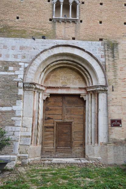
Tolentino

Tolentino is located in the mid-valley of Chienti. The town became an urban commune in AD 1099 and preserves a medieval layout, defined by the 13th centurywalls. Among the most notable medieval and early modern buildings and infrastructures, are the Cathedral of San Catervo (with early Christian and medieval phases), the monastic complex of San Nicola, founded in the 13th century, the romanesque Church of San Giacomo, the romanesque-gothic church of San Francesco, the romanesque house of Friar Sillabus (13th century),the 14th century ‘medieval house’ in via Ozeri, the 13th century city gates and walls, and the Ponte del Diavolo (Devil’s bridge), completed in 1268. The communal palace has medieval origins, but was re-modelled in 1860. My photographic report starts from this structure, as it is directly linked to the local seismic culture (the palace was affected by an earthquake in 1703). Then I present some damage visible in the cathedral of San Protervo, the church of San Giacomo, and the medieval Devil’s bridge. Finally some pictures focus on the town walls and gates of Tolentino, which present possible past seismic damage and show a characteristic building technique which might relate to an earthquake resistant design.

dsc_0046
The communal palace of Tolentino, on the left, and the church of Saint Francesco.
tolentino-1703
Tolentino, the communal palace as depicted during the 1703 earthquake.
san-francesco-facade
Neoclassic façade of the church of Saint Francesco. Penetrative cracks.The upper fracture corresponds with the borders of a walled window.
cathedral-general
The apsidal area of the cathedral of Saint Protervo. Seismic damage here is easily recognisable.
tolentino-cathedral-2
Saint Catervo. Vertical and shear cracks observable on the external wall of the apse.
tolentino-catedral-1
Saint Catervo, bell tower. The gothic arch is deformed. Some of its elements are displaced and extruded.
san-giacomo
The apse and the bell tower of the romanesque church of Saint Giacomo
san-giacomo-cracks
Saint Giacomo. A sub-vertical fracture is visible in the centre of the wall, whereas a shear crack characterises the upper right corner of the structure. It moves along the interface between the wall and a later repair, as underline by the insertion of an iron chain.
san-giacomo-bell-tower
San Giacomo, bell tower. A X-shaped crack and the extrusion of the base of the bell tower’s cupola is visible. This damage is probably related to the load caused by the weight of the concrete (?) roof.
ponte-diavolo-2
The 13th century Devil’s Bridge (Ponte del Diavolo). The bridge fortunately did not suffer any structural damage.
ponte-diavolo-1
Devil’s Bridge. The shrine of the Holy Virgin, erected in 1524, was badly damaged and already embedded with steel wire ropes at the time of my survey.
gate-1-a
Porta Marina (Marina Gate, also known as the Monastery Gate). Erected during the 14th century, this gate controlled the access to Tolentino along the Roman via Flaminia.
gate-1-b
Porta Marina. The gate was badly damaged by the 2016 earthquakes. However, it could also have suffered damage in previous seismic events. The left part of the external gate collapsed and later repaired in bricks. The upper machicolation apparently belongs to this later phase.
gate-1-c
View of the side of the upper machicolation. Associated with penetrative cracks,  the deformation of one of the structure’s arches is visible.

wall-1

The medieval town walls of Tolentino were erected in the 13th century but later re-modelled in the 15th century (Semmoloni 2016, Tolentino. Guida all’arte e alla storia, p.154). They are constructed using a particular building technique, characterised by alternating courses of sand stone and bricks. In the Eastern Mediterranean this technique is known as hatil, which is a common feature in Bizantine and Ottoman architecture.

wall-2
Close-up of the ‘hatil’ of the walls of Tolentino. This technique has been demonstrated to be earthquake resistant, as the alternating materials work as vertical and horizontal seismic loads absorbers (Bankoff 2015, Designed by disasters. Seismic architecture and cultural adaptation to earthquakes: 58). The possibility that this technique was adopted here with this function in mind should be explored in greater detail.  

hatil-1

hatil 2.JPG
This technique is not exclusively employed in the urban defences of Tolentino. It is also possible to find it in medieval buildings (above) and property enclosures (below).
palace frate sillabo.JPG
The technique of alternating bricks and sand stones probably post-dates the Romanesque period, as in Tolentino this period seems to be characterised by the exclusive use of worked stones. This is the so-called house of friar Sillabus, a building dating back to the 12th century. Fortunately, it was not damage by the 2016 seismic sequence.

Caldarola

Caldarola is a town located about 25 kilometres southwest of Macerata which flourished during the late Middle Ages. At its amazing historic centre are the Palace and Castle Pallotta (documented since the 9th century), named after the cardinal who patronised the re-modelling of these buildings in the late 16th century. At the time of my visit, the entire centre was considered the ‘red zone’, and all the inhabitants living in this area had been evacuated. Therefore, the access to the town was not permitted without the escort of a fireman to supervise the area. Here, I would like to thank Davide Morelli who escorted me in Caldarola. Below are some images of the damaged historic buildings I saw there.
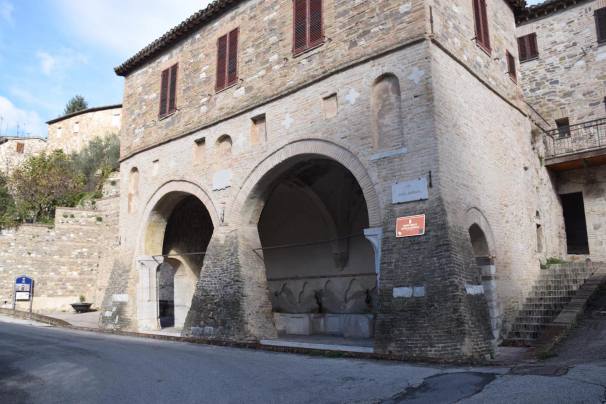
DSC_0556.JPG
The access (SP 502) to the deserted town of Caldarola.
DSC_0559.JPG
Palazzo Pallotta, 16th century. Deformed arches and architrave of the main façade. This is not an effect of the 2016 earthquake. Past seismic events or the alteration of soft sediments on which the building was built are the most likely causes for such a deformation.
DSC_0571.JPG
Deformation in a medieval arched door. Later reinforced with a new structure in brick. Clearly, this is not related to the 2016 seismic sequence.
dsc_0573
A crack caused by the 2016 seismic sequence corresponds with the interface between the buildings phases.
dsc_0590
The castle of Caldarola. Note the destruction interface in the upper part of the tower, later superimposed by a reconstruction.
dsc_0570
A semi-destroyed chimney in the castle of Caldarola.
dsc_0582
A rotated chimney in the castle of Caldarola.
dsc_0594
Caladarola, church of Santa Caterina. Detachment of the tympanum with debris still in situ.

San Severino Marche

San Severino is another wonderful medieval centre, located along the river Potenza about 25 kilometres southwest of Macerata. The medieval town developed around a hill fort occupied since the Iron Age, and later became a Roman town under the name of Septempeda. During my visit, I had the chance to survey the top area of Monte Nero, where the medieval castle and the dome of San Severino (attested from the 10th century) lie, along with the southern slopes of the hill. I was unable to visit the urban agglomerate which developed at the foot of Monte Nero, around the majestic Piazza del Popolo. The pictures below show recent and past seismic damage which affected some of the medieval buildings across this site. In particular, the area of the castle was severely affected by the 1997 Umbria earthquake.

dsc_0159
The dome of San Severino. The medieval façade of the church shows, on the right upper corner of the doorway, an evident collapse interface. It is surmounted by a 14th century phase.
dsc_0165
Close-up of the interface between the two phases.
dsc_0162
The dome’s doorway is deformed and tilted towards the right.
dsc_0186
The bell-tower was provided with massive buttresses built at its base. The buttress photographed in the picture reemploys materials from the romanesque façade.
DSC_0231.jpeg
Upper part of San Severino dome’s bell-tower. One of the 14th century biphoras is deformed and appears restored. This damage is possibly related to the 1997 earthquake.
dsc_0198
The communal tower, dating to the 13th century. It is slightly tilted, and was severely affected by the 1997 Umbria earthquake.
dsc_0254
Penetrative fracture in the gothic arch of the tower’s door.
dsc_0243
Another penetrative crack, possibly due to seismic loads, visible although repaired in the romanesque base of the tower.
dsc_0315
Sub-vertical cracks in the wall of the medieval monastery of the Clarisse, which defines the western side of the hilltop area. As in some cases illustrated above,  the crack on the left follows an interface between two architectural phases. The latter is clearly a repair of a collapsed wall, as underlined by the missing part of the medieval window on the left. This repair employs a technique alternating bricks and reused stone, similar to the technique we have seen employed in Tolentino.
dsc_0284
Palazzo Consolare. The building delimits the NW corner of the castle’s square. This construction is  characterised by a complex sequence of repairs and reconstructions. Note the buttress on the left corner.
DSC_0287.jpeg
Palazzo Consolare, a walled window with a deformed arch. It is not clear whether the key-stone is dropped. However, the elements on its sides are clearly displaced. This is a typical earthquake effect recognisable on arched window or doors.
dsc_0356
The Fonte delle Sette Cannelle (Fountain of the seven springs), built in the 14th century and restored in the 16th century. It’s placed along the mid-slope of Monte Nero. Note the exaggerated buttresses reinforcing and including the colonnade of the building.
dsc_0335
The buttresses were built in order to reinforce the deformed and tilted colonnade (see above). Also a clear deformation in the 14th century arch is visible . The possibility that this damage was due to seismic load is very likely in my view.

Abbey of Saint Salvatore (or Saint Mary) in Insula -Monastero, Cessapalombo

Cessapalombo is located in the high valley of the river Fiastrone, in a wonderful position on the edge of the Monti Sibillini National Park. The Abbey of Santa Maria in Insula or San Salvatore, in the village of Monastero, was founded by San Romualdo in 1009 on the site of a former small Benedictine church dating back to the 8th century which itself had previously been built on the site of a Roman building. The monks lived there until the first half of the 11th century when they transferred to San Ginesio. When they returned in 1281, the monastic community renovated the building due to its structural problems and poor state of preservation. The 12th century Romanesque crypt is of particularly note as it is one of the few to be almost entirely preserved (source: http://www.turismomacerata.it/en/abbeys/san-salvatore-or-santa-maria-insula).

The repairs undertaken in 1281 could refer to a post-seismic restoration of the Early medieval building. As mentioned above, the area was struck by a destructive earthquake in 1279.

dsc_0623
Monastero dell’Isola. General view.
dsc_0629
Seismic damage caused by the 2016 earthquakes. Note the walls’ detachment from the upper part of the façade.
dsc_0651
Detail of the detachment from the central part of the tympanum.
dsc_0637
Detail of the in situ debris from the detached wall.
dsc_0648
Gothic window cracked by the 2016 earthquake.
dsc_0656
Another window damaged by seismic loads.
dsc_0671
The romanesque phase of the church, superimposed by later reconstructions. The upper part of this phase may be defined by phase of destruction due to seismic shock.
dsc_0667
Seismically damaged fresco of Saint George. Note the penetrative fractures crossing through the fresco and the underling wall.

San Biagio di Piobicco, Sarnano

The Abbey of San Biagio (originally known as Santa Maria) was founded in 1030 and consecrated in 1059, whilst the dedication to San Biagio dates back to the 15th century. The abbey flourished during the 11th and 12th centuries which was followed by a phase of progressive decadence ending around the middle of the 13th century when the the monks abandoned the structure. The church is the only part of the old abbey which still remains, as over time the structure has been transformed in such a way that it is difficult to identify the original layout.

The church was severely damaged by the 2016 earthquakes, as shown by the following pictures, comparing the church before and after the seismic event.

abbazia-di-piobbico-before-eq
The façade and the southern side of the church before the 2016 earthquakes. Source: pierluigitomassetti.com
untitled-1.jpg
The church after the earthquake. Note the collapse of the bell-tower in the background.
abbazia-di-piobbico-before-eq-3
The apsidal area of the abbey before the 2016 earthquake. Source: anellodeicrinali.it
after
The same area photographed after the earthquake. The bell-tower has collapsed and the tympana of the central and lateral naves are destroyed.
DSC_0757.jpeg
The church was reduced in size as shown by the central nave’s walled arch.
dsc_0759
The walling of the arch was clearly seismically-damaged, tilted and extruded from its original position.
dsc_0764
The building erected nearby the church was also badly damaged (see also below). It clearly shows at least two different architectural phases.
church-facade
The church façade has clearly been reconstructed in brick. The older phase, in stone, shows a distinctive, V-shaped, collapse interface which could be ascribed to ancient seismic damage.

Acknowledgments

I would like to thank all the fantastic people who supported me during my time spent in and around Tolentino. Firstly, all the volunteers of Protezione Civile of Feltre, with particular regards to Giorgio Bottegal (the section’s president) who very kindly brought me there, and Giangi Viezzer and Sandro Facchin who took me out to San Severino. Then I must mention the wonderful Tolentino volunteers of the soup kitchen at the Istituto Comprensivo G. Lucatelli and the fireman Davide Morelli, my exceptional guide in Caldarola. This was an eye-opening experience for me, and everything I learnt there was possible because of the support of these people. I hope this work is simply the initial phase of a more complete study which this region deserves from many points of view.

img_8736img_8737

dsc_0585

Leave a comment